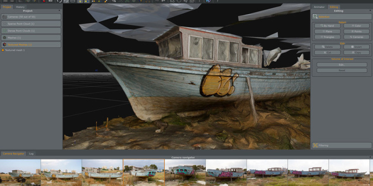
The evolution of the digital modeling landscape is being defined by several crucial Photogrammetry Software Market Trends that are fundamentally reshaping workflows, enhancing capabilities, and broadening the accessibility of the technology. The most significant and transformative trend is the deep integration of Artificial Intelligence (AI) and Machine Learning (ML) into photogrammetry software. AI algorithms are moving beyond simple image processing to automate and intelligently interpret the vast datasets produced. This includes AI-powered feature recognition for automatically identifying and classifying objects within a 3D point cloud or orthomosaic, such as identifying individual trees, buildings, roads, or even signs of infrastructure damage like cracks in a dam. This automation drastically reduces the time-consuming manual labor of data classification and analysis, allowing professionals to focus on higher-level decision-making. Furthermore, ML is being used to improve the core reconstruction process itself, helping the software make smarter decisions about camera alignment and point cloud densification, resulting in more accurate and complete models, especially in challenging environments. This trend is shifting the software from a simple reconstruction tool to an intelligent analysis platform.
Another dominant trend is the decisive shift from desktop-centric processing to cloud-based platforms and hybrid workflows. Processing large photogrammetry datasets is an incredibly computationally intensive task, often requiring expensive, high-end workstations and tying them up for hours or even days. The rise of cloud computing offers a powerful solution to this bottleneck. Cloud-based photogrammetry platforms allow users to upload their imagery and leverage the massive, scalable computing power of server farms to process the data in parallel, significantly reducing processing times. This Software-as-a-Service (SaaS) model also lowers the barrier to entry by replacing a large upfront hardware investment with a more manageable subscription fee. It facilitates collaboration, as team members from different locations can access and work with the same project data through a web browser. This trend is not just about offloading computation; it's about creating a centralized, collaborative hub for 3D data management, analysis, and sharing, making the entire workflow more efficient and accessible, particularly for large enterprises and distributed teams.
Finally, a critical technological trend is the increasing fusion of photogrammetry with other sensor data, most notably LiDAR (Light Detection and Ranging). While photogrammetry excels at creating photorealistic, textured models, it can struggle with accuracy in areas with poor texture or dense vegetation. LiDAR, on the other hand, excels at penetrating vegetation and capturing precise geometric detail, but it lacks color and texture information. The trend is towards software platforms that can seamlessly fuse the data from both sensors, combining the geometric accuracy of a LiDAR point cloud with the rich, realistic texture from photogrammetry. This data fusion approach creates a "best of both worlds" 3D model that is both geometrically precise and visually stunning. This is particularly valuable in industries like forestry, urban planning, and infrastructure management, where both the exact shape of the ground and the visual context of the features upon it are critical. This convergence of sensor technologies is driving the development of more sophisticated, multi-modal software, pushing the boundaries of what is possible in digital reality capture.
Ubicación del Autor
Outlying islands, estados unidos